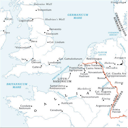
One of the great rivers in Europe, forming in ancient times the boundary between Gaul and Germany, rises in Mount Adulas (St. Gothard), not far from the sources of the Rhone, and flows first in a westerly direction, passing through the Lacus Brigantinus (Lake of Constance) till it reaches Basilia (Basle), where it takes a northerly direction, and eventually flows into the ocean by several mouths.The ancients spoke of two main arms into which the Rhine was divided on entering the territory of the Batavi, of which the one on the east continued to bear the name of Rhenus, while that on the west, into which the Mosa (Maas or Meuse) flowed, was called Vahalis (Waal). After Drusus, in B.C. 12, had connected the Flevo Lacus (Zuyder-Zee) with the Rhine by means of a canal (in making which he probably made use of the bed of the Yssel), we find mention of three mouths of the Rhine. Of these the names, as given by Pliny, are: on the west, Helium (the Vahalis of other writers); in the centre, Rhenus; and on the east, Flevum; but at a later time we again find mention of only two mouths.
The Rhine is described by the ancients as a broad, rapid, and deep river. It receives many tributaries, of which the most important are the Mosella (Moselle) and Mosa (Maas or Meuse) on the left, and the Nicer (Neckar), Moenus (Main), and Luppia (Lippe) on the right. Its whole course amounts to about 950 miles. The inundations of the Rhine near its mouth are mentioned by the ancients.
Caesar was the first Roman general who crossed the Rhine. He threw a bridge of boats across the river, probably in the neighbourhood of Cologne. There is a history of the river Rhine from Keltic to modern times by Mehlis, 3 vols. (Berlin, 1876-79).
