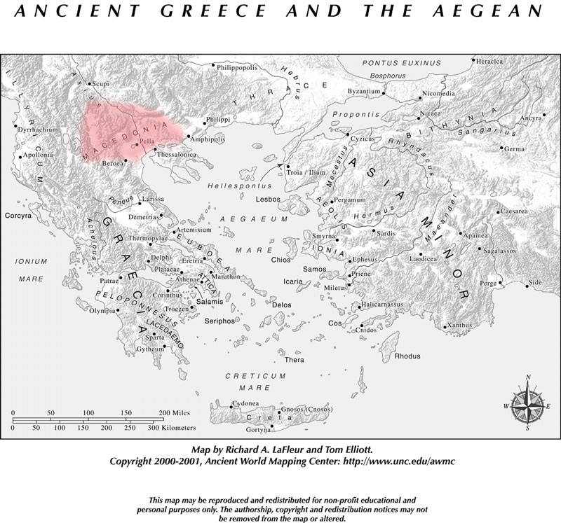
A country in Europe, north of Greece, said to have been originally named Emathia. Its boundaries before the time of Philip, the father of Alexander, were, on the south, Olympus and the Cambunian Mountains, which separated it from Thessaly and Epirus; on the east, the river Strymon, which separated it from Thrace; and on the north and west, Illyria and Paeonia. Macedonia was greatly enlarged by the conquests of Philip. He added to his kingdom Paeonia on the north; a part of Thrace on the east as far as the river Nestus, which Thracian district was usually called Macedonia Adiecta; the peninsula Chalcidicé on the south; and on the west a part of Illyria as far as Lake Lychnitis. On the conquest of the country by the Romans, B.C. 168, Macedonia was divided into four districts, independent of one another; but the whole country was formed into a Roman province after the conquest of the Achaeans in 146.Macedonia may be described as a large plain, surrounded on three sides by lofty mountains. Through this plain, however, run many smaller ranges of mountains, between which are wide and fertile valleys, extending from the coast far into the interior. The chief mountains were Scordus, or Scardus, on the northwest frontier, towards Illyria and Dardania; further east Orbelus and Scomius, which separated it from Moesia; and Rhodopé, which extended from Scomius in a southeasterly direction, forming the boundary between Macedonia and Thrace. On the southern frontier were the Cambunii Montes and Olympus. The chief rivers were in the direction of east to west-- the Nestus, the Strymon, the Axius, the largest of all, the Ludias or Lydias, and the Haliacmon. The chief cities were Aegae and Pella, the capitals, and Pydna, Potidaea, Olynthus, Amphipolis, and Philippi. The great bulk of the inhabitants of Macedonia consisted of Thracian and Illyrian tribes. At an early period some Greek tribes settled in the southern part of the country. They are said to have come from Argos, and to have been led by the three sons of Temenus, the Perdiccas, the youngest of the three, was looked upon as the founder of the Macedonian monarchy. A later tradition, however, regarded Caranus, who was also a Heraclid from Argos, as the founder of the monarchy. These Greek settlers intermarried with the original inhabitants of the country. The dialect which they spoke was akin to the Doric, but it contained many barbarous words and forms; and the Macedonians accordingly were never regarded by the other
Very little is known of the history of Macedonia till the reign of Amyntas I., who was a contemporary of Darius Hystaspis; but from that time their history is more or less intimately connected with that of Greece, till at length Philip, the father of Alexander the Great, became the virtual master of the whole of Greece. The conquests of Alexander extended the Macedonian supremacy over a great part of Asia; and the Macedonian kings continued to exercise their sovereignty over Greece till the conquest of Perseus by the Romans, in B.C. 168, brought the Macedonian monarchy to a close. See Abel, Makedonien vor König Phillipp (Leipzig, 1847); Döll, Geographie der alt. Makedoniens (1891); Henzey and Daumet, Mission Archéologique de Macédonie, 2 vols. (Paris, 1876); Curteis, Rise of the Macedonian Empire (N. Y. 1878); and the articles Alexander; Perdiccas; Philippus. (Harpers Dictionary of Classical Antiquities, 1898)
